
")
SEAFOREST LIFE BROCHURE
Newly released the SeaForest LIFE brochure.
The publication, the result of the collaboration between the various project partners, summarizes the objectives and shows the first results that SeaForest LIFE is obtaining in the fight against climate change and the conservation of Posidonia oceanica meadows in the project areas.
We are trying to set up a system that can be exported throughout the Mediterranean Sea and that, through the sale of carbon credits deriving from conservation actions aimed at Posidonia oceanica, allows us to counter CO2 emissions into the atmosphere and economically recognize the ecosystem services that this marine plant offers to all of us.
The brochure will be presented in Hannover at the 10th world conference of the Ecosystem Services Partnership (ESP).
Download the PDF version of the brochure and find out more about the SeaForest LIFE project.


Monitoring visit 2019
MONITORING VISIT
The monitoring visit 2019 to our project was held on Tuesday 1st October.
An important moment of evaluation and camparison with the monitor of the NEEMO - THIMESIS team.

Starting conference SeaForest LIFE
SEAFORESTLIFE STARTING CONFERENCE - SEA FORESTS: conserve Posidonia oceanica to combat climate change
The initial conference of the SeaForest LIFE project will take place on 30 September 2019, in Rome at the Higher Institute for Environmental Protection and Research (ISPRA) in Via Brancati 48.
The event will focus on the aims and objectives of the project, illustrating the potential of Posidonia in Italian protected areas belonging to the Natura 2000 network. These environments are in fact an opportunity for the environment and the community. Good practices for their proper management will be discussed and shared.
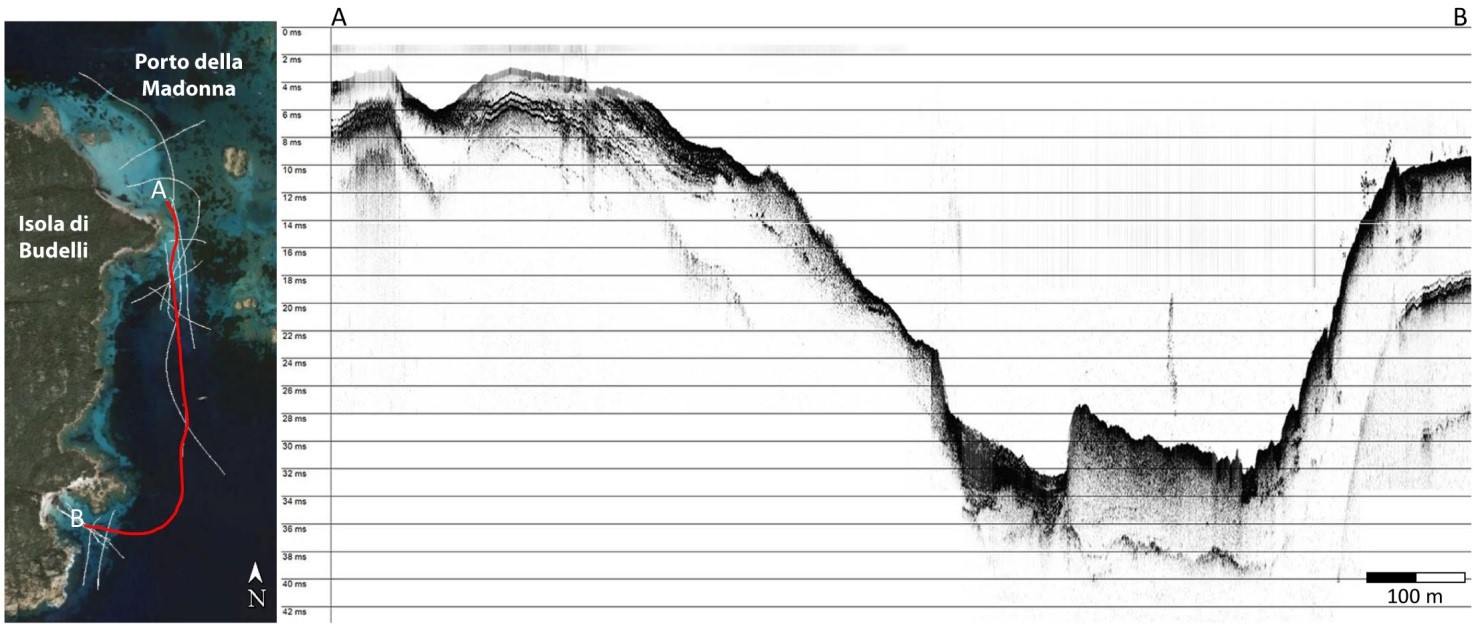
ONGOING SEISMIC SURVEYS
The project partner CNR - IAS of Oristano (Institute for the study of anthropogenic impacts and sustainability in the marine environment) is processing seismic data in the area of the National Park of the La Maddalena Archipelago . These data will be useful for some project actions: A1 (Quantification of carbon deposits and rate of change in relation to habitat degradation), A1.1 (Cartography and characterization of the 1120 * habitat for the protected areas involved in the project); C2 (Definition of Good Practices for the Conservation of Habitat 1120 *: Management Plan for Anchors and Moorings), C3 (Definition of Good Practices for Conservation of the 1120 Habitat *: Interventions on Moorings). The elaboration will also be useful to provide information on the conservation of the Posidonia oceanica habitat and for the management of anchorages and moorings.

The illustrated seismic section shows the main acoustic facies detected in the Porto della Madonna (La Maddalena National Park, Sardinia)
SeaForest LIFE: WORK IN PROGRESS...
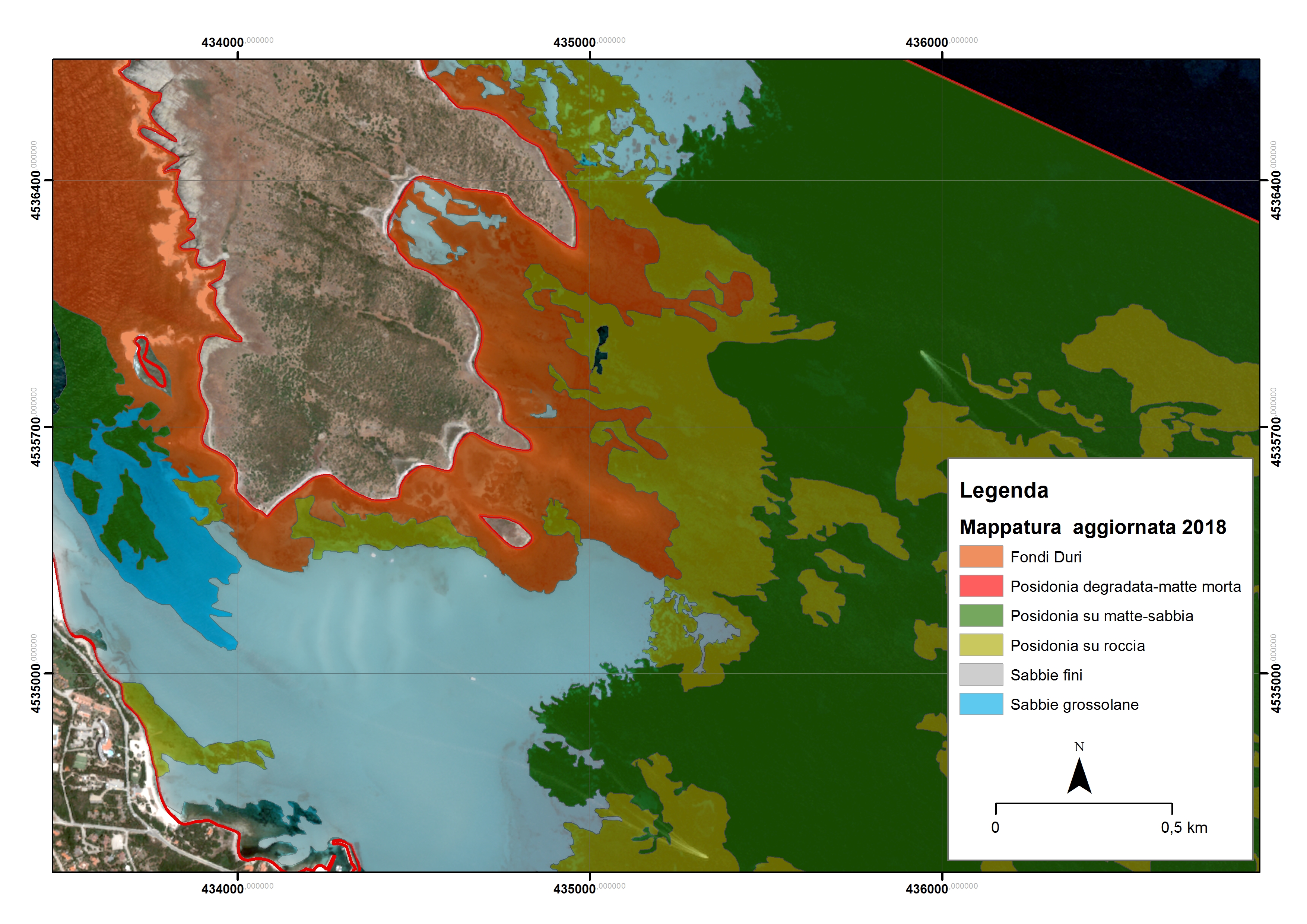
ISPRA, one of the partners of the SeaForest LIFE project, is processing high resolution Pleiades multispectral satellite images, to update the distribution of Posidonia oceanica grasslands in the parks involved in the project: La Maddalena Archipelago National Park, Asinara National Park and the Cilento National Park, Vallo di Diano and Alburni. The Pleiades satellite images were previously corrected with the radiometric correction algorithm of the water column, using the Lyzenga 1978 method "depth-invariant index". The mapping of the P. oceanica meadows was carried out with the classification software object oriented Ecognition.
The updated data on the distribution of the Posidonian meadows were compared with the mapping of marine phanerogams financed by the Ministry of the Environment and dating back to 1999. Both mapping datasets will be used to estimate the production of Blue Carbon and Carbonsink using the Invest model "Natural Capital Project”.

Asinara National Park: Color orthophoto year 2000 (WMS service National cartographic portal)

Asinara National Park: Pleiades Multispectral Satellite image 2018 (PANDA ESA service - Copernicus)

Asinara National Park: updated cartography regarding Posidonia oceanica meadows distribution
